Unusual cloud formations over New Zealand

© Piers Fuller/Fairfax NZ
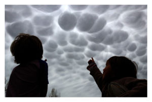
Unusual Sight: Japhy and Enzo Fuller look at the strange clouds over Masterton.
Unusual Sight: Japhy and Enzo Fuller look at the strange clouds over Masterton.
Wairarapa News journalist Piers Fuller was on the lawn outside his home east of Masterton at about 6pm last night, videoing an impromptu rugby game between his sons Japhy, 6, Enzo, 5 and daughter Juno, 2, when he noticed the sky looked "weird".
"I stopped and said, hey, look at these freaky clouds."
Commenters on the Wairarapa News Facebook page thought the clouds were Mammatus clouds, also known as "mammary clouds".
Metservice meteorologist Daniel Corbett agreed, saying mammatus normally form as a result of sinking air, hence their downward udder-like appearance, and often occur in the base of the anvil of a cumulonimbus, or thunderstorm, cloud.
However in this particular case the explanation was a warm north-west wind lifting up over the Tararua Range then falling into the leading edge of a rainy front creeping over the lower North Island last night, he said.
"When [the north-wester] comes over the Tararuas it's almost like a ski slope, it lifts the clouds then pushes them down... that downward motion can help create that type of formation."
Source: The Dominion Post


No comments