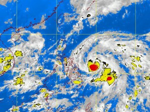
 MANILA, Philippines — Tropical Storm Chedeng continued to bear down on the Philippines with greater force Tuesday, compelling the weather bureau to issue warnings in seven provinces in the Bicol and Eastern Visayas regions that were already beginning to feel the effects of the country’s third cyclone this year. As of 10 a.m. Tuesday, the Philippine Atmospheric, Geophysical, and Astronomical Services Administration (Pagasa) said, Chedeng was located 490 kilometers east of Borongan, Eastern Samar, with maximum sustained winds of 105 kilometers per hour near the center and gusting up to 135 kph. The storm had decelerated, however, and was moving west northwest at 13 kph, slower than its 15 kph speed on Monday. Weather forecaster Robert Sawi said Chedeng was expected to intensify into a typhoon within the next 24 hours with center winds of at least 117 kph. If it stays on its present course, Chedeng is expected to make landfall in the Cagayan-Isabela area on Friday afternoon. Sawi said the storm’s path could still change, however. A high-pressure area could block the disturbance from heading farther north and push it to move west to the Bicol provinces, he said. The effects of the storm started to be felt in the Bicol and Eastern Visayas on Tuesday, with Pagasa raising storm signal No. 1 over Catanduanes, Camarines Sur, Albay, Sorsogon and the three Samar provinces. Starting Thursday, Sawi said, heavy rains would prevail in the provinces of Isabela, Quezon, and Aurora. As the storm tracks northwest, stormy weather would be experienced in Central and Northern Luzon on Friday and Saturday, the Pagasa official said. “It is unsafe to travel by land, air on sea during these days,” Sawi said. Pagasa officials said Northern Luzon should brace itself for plenty of rain. –Inquirer.net
Random Posts
Powered by Blogger.
Nibiru
NATURAL DISASTERS
EARTH CHANGES
‹
›


No comments